
Archivo:Baltimore-Washington Parkway.jpg
Ver la imagen en su resolución original (4461 × 6608 píxeles; tamaño de archivo: 8,71 MB; tipo MIME: image/jpeg)
Resumen
| Descripción |
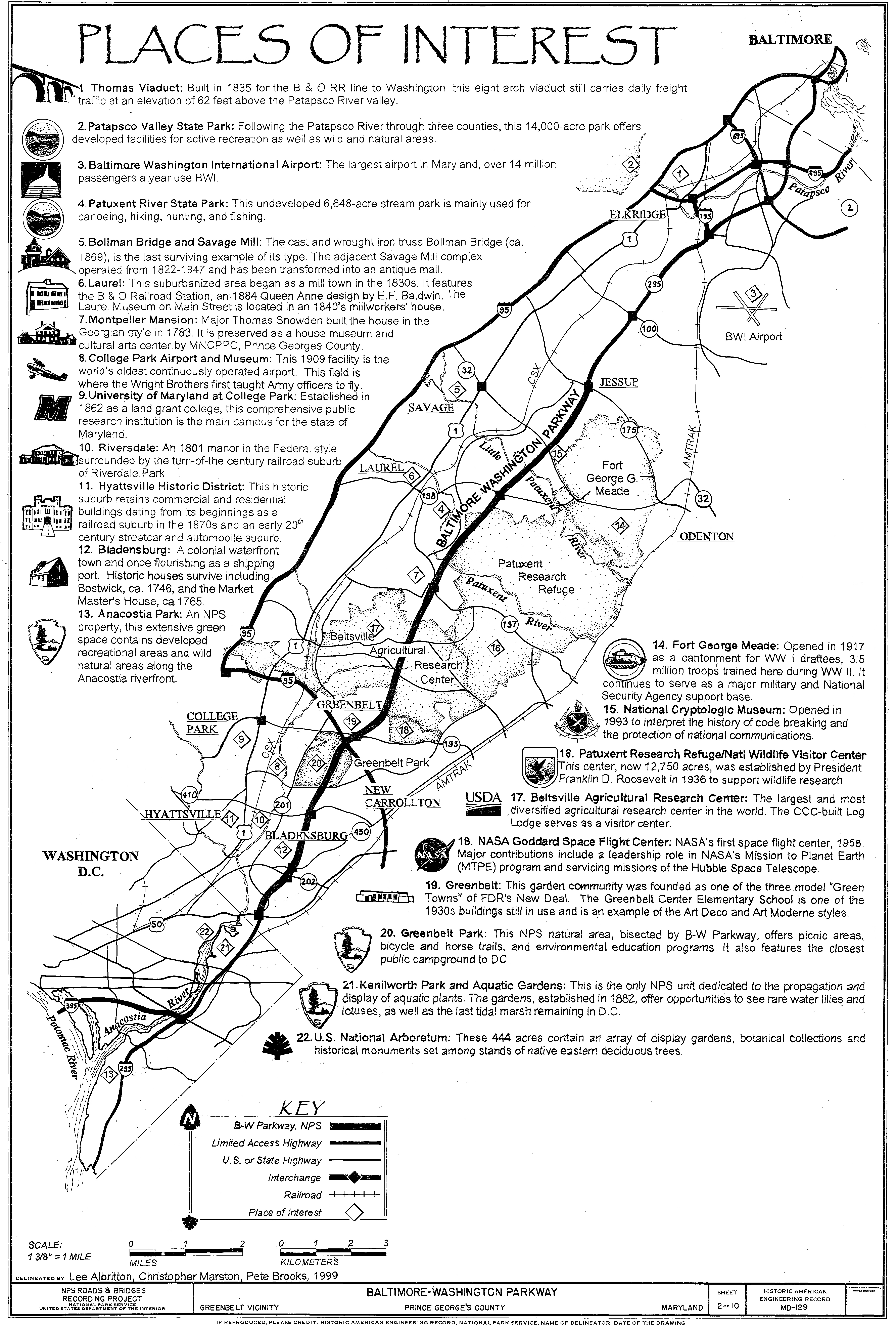
English: Historic American Engineering Record (HAER) measured drawing with illustrations and descriptions of places of interest located within close proximity to the Baltimore-Washington Parkway |
||||
| Fecha | |||||
| Fuente |
|
||||
| Autor | Historic American Engineering Record, National Park Service; Lee Albritton, Christopher Marston, Pete Brooks delineators | ||||
| Permiso (Reutilización de este archivo) |
|
||||
| Otras versiones |
.jpg .jpg Master .tif |

| Ubicación del objeto | | Ubicación de esta y otras imágenes en: OpenStreetMap |
|---|
Title: Baltimore-Washington Parkway, Greenbelt Vicinity, Prince George's County, Maryland Sheet 2 of 10, Historic American Engineering Record, MD-129
Other Title: Places of Interest Map - Baltimore-Washington Parkway, Greenbelt, Prince George's County, MD DRAWINGS FROM SURVEY HAER MD-129; image 2
Part of: Baltimore-Washington Parkway, Greenbelt, Prince George's County, MD
Other Title: Baltimore-Washington Parkway
Contributor Names:
- Historic American Engineering Record, creator
- National Park Service
- Public Roads Administration
- National Capital Park & Planning Commission
- Delano, Frederick
- Grant, Ulysses S
- Olmsted, Frederick Law
- Clarke, Gilmore D
- Commission of Fine Arts
- Eliot, Charles, II
- Jeffers, Thomas C
- Greenleaf, James
- Sherrill, C. O.
- National Capital Park Commission
- Mackall, John N.
- Powell, Victor
- Cammerer, Arno B.
- Wolman, Abel
- Middleton, E. G.
- War Department
- Nolen, John, Jr.
- Delano, Frederic
- Maryland State Roads Commission
- U.S. Department of Agriculture
- W.N. Brown, Incorporated
- Winter, F. E.
- Tarwater, E. L.
- McDonald, Thomas H.
- Demaray, A. E.
- Wright Contracting Company
- J. O. and C. M. Stuart, Inc.
- Contee Sand and Gravel Company
- H. N. McNutt and Williams Construction Company
- Taylor Construction Company
- T. E. Ritter Corporation
- Lehigh Portland Cement Company
- Penn Dixie Cement Company
- Suburban Engineering and Construction Company
- Rea Construction Company
- Taylor and Keebler, Inc.
- Geisler, C. D.
- Berger, F. W.
- Haussmann, William M.
- Annese, Dominic
- Rensch, Elwood
- Brooklyn Engineering Corporation
- Allied Contractors, Inc.
- Chas. H. Tompkins Company
- Troitino and Brown Company
- Contee Sand and Gravel Company
- F. Blessing and Son
- Woodbine Nurseries
- Maryland State Highway Administration
- Federal Highway Administration
- Concrete General Inc.
- Smith-Midland Company
- Flippo Construction Company
- Cassara, Francesca, landscape architect
- Marston, Christopher, project manager
- Davis, Tim, project manager
- Croteau, Todd, project manager
- Christianson, Justine, transmitter
- Albritton, Lee, delineator
- Cabeza, Ana, delineator
- Simandl, Tim, historian
- Duensing, Dawn, historian
- Lowe, Jet, photographer
- Rosenthal, James, photographer
- Dymek, Ana, delineator
- Matulac, Michelle, delineator
- Fernandez, Katalina, delineator
- Brooks, Pete, delineator
Created / Published: Documentation compiled after 1968
Subject Headings:
- parkways - transportation - overpasses - rigid frames - concrete arch bridges - stonework (granite) - voussoirs - walls - interchanges - cloverleafs (interchanges) - steel girder bridges - concrete abutments - underpasses - concrete girder bridges - grade separations - stone cladding - asphalt pavements - culverts - reinforced concrete construction - barriers - precast concrete construction - Maryland -- Prince George's County -- Greenbelt
Latitude / Longitude: 38.939192,-76.914206
Notes:
- Significance: The federal section of the Baltimore-Washington Parkway was constructed to provide a dignified entrance to the nation's capital. The parkway also provided a new traffic artery that relieved congestion on U.S. Route 1 (Baltimore-Washington Boulevard). The parkway was constructed to connect federal installations, including Fort George Meade and the Beltsville Agricultural Research Center (USDA), to the District of Columbia. The parkway was considered a vital defense road during World War II and the Cold War.
- Unprocessed Field note material exists for this structure: N745
- Survey number: HAER MD-129
- Building/structure dates: 1942-1954 Initial Construction
- Building/structure dates: 1957 Subsequent Work
- Building/structure dates: 1962 Subsequent Work
- Building/structure dates: 1990-1996 Subsequent Work
- Building/structure dates: ca. 2000 Subsequent Work
Medium:
- Photo(s): 49
- Color Transparencies: 2
- Measured Drawing(s): 10
- Data Page(s): 146
- Photo Caption Page(s): 5
Call Number/Physical Location: HAER MD,17-GRBLT.V,1-
Source Collection: Historic American Engineering Record (Library of Congress)
Repository: Library of Congress Prints and Photographs Division Washington D.C. 20540 USA
Control Number: md1496
Rights Advisory: No known restrictions on images made by the U.S. Government; images copied from other sources may be restricted.
Online Format: image; pdf
Description: Photo(s): 49 | Color Transparencies: 2 | Measured Drawing(s): 10 | Data Page(s): 146 | Photo Caption Page(s): 5
Registro original de carga
- 2006-05-15 21:40 Daderot 4461×6608×8 (9131954 bytes) Baltimore-Washington Parkway - Baltimore, MD to Washington, DC. This image is a cropped version of a drawing from the Library of Congress online collection; see catalog information below. The image is in the public domain since it was produced by the Unit
Historial del archivo
Haz clic sobre una fecha y hora para ver el archivo tal como apareció en ese momento.
| Fecha y hora | Miniatura | Dimensiones | Usuario | Comentario | |
|---|---|---|---|---|---|
| actual | 15:02 1 jul 2008 | | 4461 × 6608 (8,71 MB) | File Upload Bot (Magnus Manske) | {{BotMoveToCommons|en.wikipedia}} {{Information |Description={{en|Baltimore-Washington Parkway - Baltimore, MD to Washington, DC. This image is a cropped version of a drawing from the Library of Congress online collection; see catalog information below. |
Usos del archivo
La siguiente página usa este archivo:
Uso global del archivo
Las wikis siguientes utilizan este archivo:
- Uso en en.wikipedia.org
- Uso en www.wikidata.org