
Archivo:Cerros colorados res.jpg

Tamaño de esta previsualización: 600 × 600 píxeles. Otras resoluciones: 240 × 240 píxeles · 480 × 480 píxeles · 768 × 768 píxeles · 1024 × 1024 píxeles · 2048 × 2048 píxeles · 5237 × 5237 píxeles.
Ver la imagen en su resolución original (5237 × 5237 píxeles; tamaño de archivo: 8,8 MB; tipo MIME: image/jpeg)
Resumen
| Descripción |
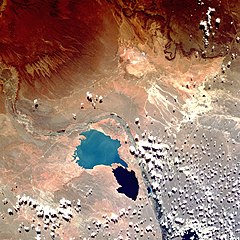
English: Shuttle image of "Cerros Colorados Complex", province of Neuquén, Argentina, March 1990
|
| Fecha | |
| Fuente | http://eol.jsc.nasa.gov/sseop/EFS/photoinfo.pl?PHOTO=STS036-80-62 |
| Autor | Image Science & Analysis Laboratory, NASA Johnson Space Center |
| Posición de la cámara | | Ubicación de esta y otras imágenes en: OpenStreetMap |
|---|
Este archivo fue catalogado por Johnson Space Center de la Administración Nacional de Aeronáutica y del Espacio (NASA) de los Estados Unidos de Américabajo el identificador de foto: STS036-80-62.Esta etiqueta no indica el estado de los derechos de autor del trabajo adjunto. Se requiere una etiqueta de derechos de autor normal. Para más información vea Commons:Sobre las licencias. Otros idiomas:
|
Licencia
"The Gateway to Astronaut Photography of Earth". Imagen cortesía de Image Science & Analysis Laboratory, NASA Johnson Space Center.
Fuente de la foto: STS036-80-62.
|
Historial del archivo
Haz clic sobre una fecha y hora para ver el archivo tal como apareció en ese momento.
| Fecha y hora | Miniatura | Dimensiones | Usuario | Comentario | |
|---|---|---|---|---|---|
| actual | 15:38 7 ago 2013 | | 5237 × 5237 (8,8 MB) | Ras67 | high resolution |
| 18:49 26 oct 2007 |  | 640 × 640 (180 kB) | Denniss | ||
| 20:16 15 feb 2007 |  | 600 × 600 (103 kB) | Rosarinagazo | Shuttle image of "Cerros Colorados Complex", province of Chubut, Argentina Author: NASA http://en.wikipedia.org/wiki/Image:Cerros_colorados_res.jpg Category:Dams |
Usos del archivo
Las siguientes páginas usan este archivo:
Uso global del archivo
Las wikis siguientes utilizan este archivo:
- Uso en de.wikipedia.org
- Uso en en.wikipedia.org
- Uso en eo.wikipedia.org
- Uso en fr.wikipedia.org
- Uso en gl.wikipedia.org
- Uso en lt.wikipedia.org
- Uso en no.wikipedia.org
- Uso en uk.wikipedia.org
- Uso en www.wikidata.org
- Uso en zh.wikipedia.org