
Archivo:East African oryx Oryx beisa distribution map 2.png

Tamaño de esta previsualización: 383 × 599 píxeles. Otras resoluciones: 153 × 240 píxeles · 568 × 889 píxeles.
Ver la imagen en su resolución original (568 × 889 píxeles; tamaño de archivo: 739 kB; tipo MIME: image/png)
Resumen
| Descripción |
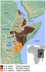
English: Geographical distribution of the East African oryx Oryx beisa. The map was created using the Generic Mapping Tools, GMT, version 5.1.2. |
| Fecha | |
| Fuente |
Trabajo propio utilizando:
Este mapa fue creado con GMT. |
| Autor | Darekk2 using the IUCN Red List spatial data and GLOBE grids |
Licencia
Attribution: The author of the work and
- the IUCN Red List spatial data.
IUCN (International Union for Conservation of Nature) 2008. Oryx beisa. In: IUCN 2015. The IUCN Red List of Threatened Species. Version 2015.2. http://www.iucnredlist.org. Downloaded on 14 July 2015. - GLOBE grids
(for credits see the Source section)
The NGDC in it's copyright notice says:
As required by 17 U.S.C. 403, third parties producing copyrighted works consisting predominantly of the material produced by U.S. government agencies must provide notice with such work(s) identifying the U.S. Government material incorporated and stating that such material is not subject to copyright protection within the United States. (...).
Este archivo está disponible bajo la licencia Creative Commons Attribution-Share Alike 4.0 International.
Atribución: The author of the work
and the IUCN Red List spatial data
and GLOBE
(see above and the Source section)
and the IUCN Red List spatial data
and GLOBE
(see above and the Source section)
- Eres libre:
- de compartir – de copiar, distribuir y transmitir el trabajo
- de remezclar – de adaptar el trabajo
- Bajo las siguientes condiciones:
- atribución – Debes otorgar el crédito correspondiente, proporcionar un enlace a la licencia e indicar si realizaste algún cambio. Puedes hacerlo de cualquier manera razonable pero no de manera que sugiera que el licenciante te respalda a ti o al uso que hagas del trabajo.
- compartir igual – En caso de mezclar, transformar o modificar este trabajo, deberás distribuir el trabajo resultante bajo la misma licencia o una compatible como el original.
Historial del archivo
Haz clic sobre una fecha y hora para ver el archivo tal como apareció en ese momento.
| Fecha y hora | Miniatura | Dimensiones | Usuario | Comentario | |
|---|---|---|---|---|---|
| actual | 23:18 19 jun 2016 | | 568 × 889 (739 kB) | Darekk2 | added border between Sudans |
| 17:07 15 jul 2015 |  | 568 × 889 (738 kB) | Darekk2 | thinner borders in the inset map | |
| 16:51 15 jul 2015 |  | 568 × 889 (739 kB) | Darekk2 | thinner borders in the inset map | |
| 15:11 15 jul 2015 |  | 568 × 889 (739 kB) | Darekk2 | latin names to oblique (italics) | |
| 14:44 15 jul 2015 |  | 568 × 889 (738 kB) | Darekk2 | User created page with UploadWizard |
Usos del archivo
La siguiente página usa este archivo:
Uso global del archivo
Las wikis siguientes utilizan este archivo:
- Uso en en.wikipedia.org
- Uso en hu.wikipedia.org
- Uso en it.wikipedia.org
- Uso en ka.wikipedia.org
- Uso en ko.wikipedia.org
- Uso en nl.wikipedia.org
- Uso en pl.wikipedia.org
- Uso en ru.wikipedia.org
- Uso en sco.wikipedia.org
- Uso en sr.wikipedia.org
- Uso en vi.wikipedia.org