
Archivo:Maui wildfires 2023.jpg

Ver la imagen en su resolución original (2766 × 2017 píxeles; tamaño de archivo: 3,45 MB; tipo MIME: image/jpeg)
Resumen
| Descripción |
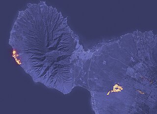
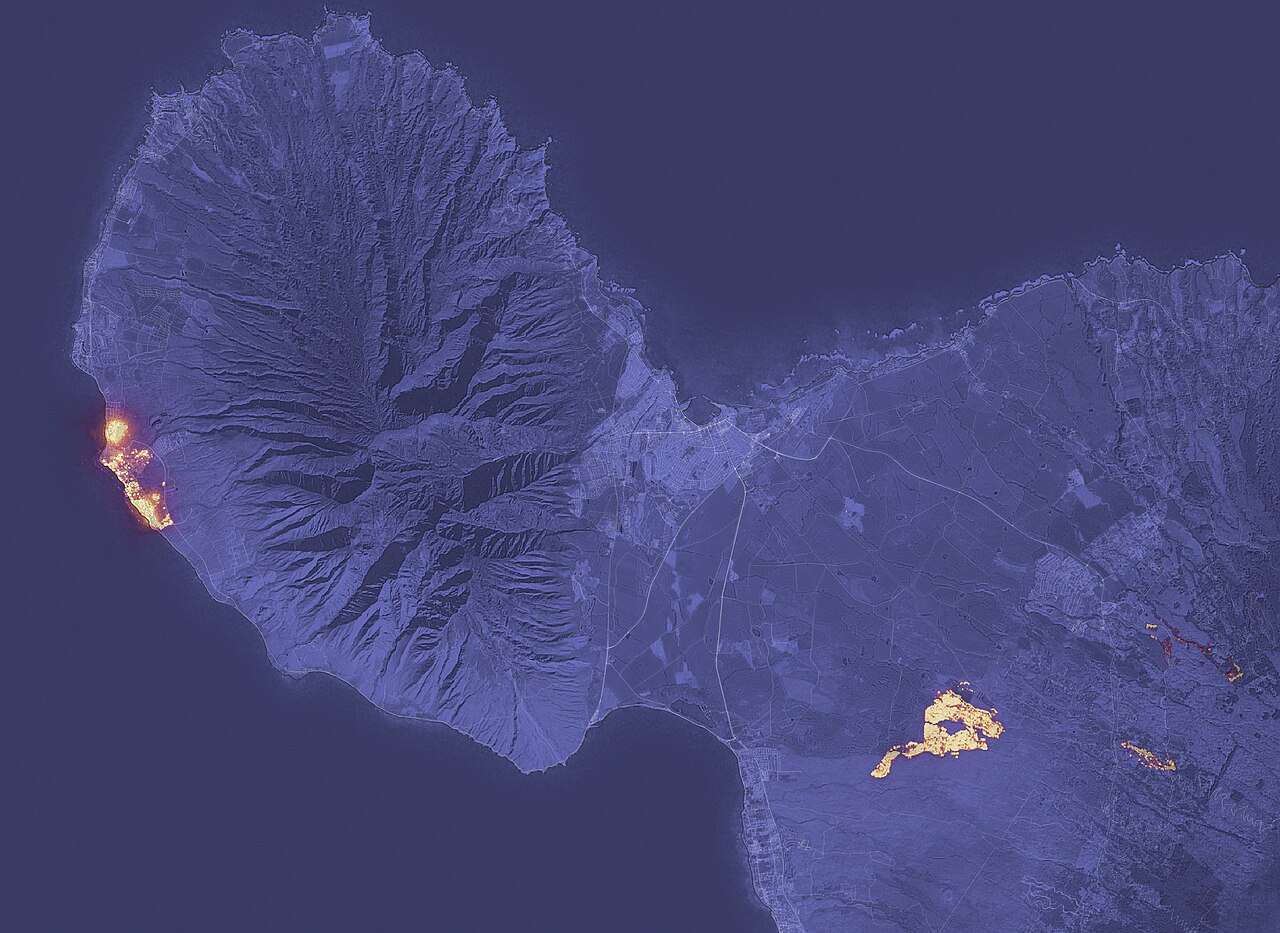
English: A fast-moving wildfire has devastated the historic town of Lahaina on Maui, Hawaii’s second-largest island.
The image above shows the signature of the fire at 10:25 p.m. local time on August 8, 2023, as observed by the Operational Land Imager (OLI) on the Landsat 8 satellite. Much of Lahaina, a town with a resident population of nearly 13,000 people, appeared to be on fire at the time of the image. Another large fire burned northeast of Kihei. The image was composed from OLI observations of shortwave infrared light (band 6). Infrared observations are useful for distinguishing the locations of active fires, shown here in yellow. The shortwave infrared data were overlaid on a natural-color mosaic image based on Landsat 8 observations for added geographic detail. The fires occurred during a period of strong winds and dry conditions in Maui. Between August 7-9, 2023, the island experienced peak gusts that ranged from 45 to 67 miles (72 to 107 kilometers) per hour, according to the National Weather Service. The presence of a strong high-pressure area to north of the island and Hurricane Dora to the south may have helped fuel the winds. An analysis by the U.S. Drought Monitor shows that the southwestern part of the island was in the midst of moderate to severe drought at the time of the fires. Maui County has reported damage to hundreds of structures, with widespread damage in the Lahaina harbor area. On August 9, authorities were continuing to conduct search and rescue operations. NASA’s Earth Applied Sciences Disasters program area has been activated in support of the fires in Hawaii. As new information becomes available, the team will be posting maps and data products on its open-access mapping portal. |
| Fecha | |
| Fuente | https://earthobservatory.nasa.gov/images/151688/devastation-in-maui |
| Autor | NASA - NASA Earth Observatory |
Licencia
| Este archivo es de dominio público porque fue creado por la NASA. Las políticas sobre copyright de la NASA estipulan que «el material de la NASA no está protegido con copyright a menos que se indique lo contrario». (Políticas sobre copyright de la NASA o Políticas sobre la utilización de imágenes del Jet Propulsion Laboratory). | ||
 |
Advertencias:
|
Historial del archivo
Haz clic sobre una fecha y hora para ver el archivo tal como apareció en ese momento.
| Fecha y hora | Miniatura | Dimensiones | Usuario | Comentario | |
|---|---|---|---|---|---|
| actual | 06:40 11 ago 2023 | | 2766 × 2017 (3,45 MB) | JoleBruh | Uploaded a work by NASA - NASA Earth Observatory from https://earthobservatory.nasa.gov/images/151688/devastation-in-maui with UploadWizard |
Usos del archivo
La siguiente página usa este archivo:
Uso global del archivo
Las wikis siguientes utilizan este archivo:
- Uso en ar.wikipedia.org
- Uso en be.wikipedia.org
- Uso en en.wikipedia.org
- Uso en ga.wikipedia.org
- Uso en he.wikipedia.org
- Uso en incubator.wikimedia.org
- Uso en ms.wikipedia.org
- Uso en nl.wikipedia.org
- Uso en ru.wikipedia.org
- Uso en th.wikipedia.org
- Uso en tr.wikipedia.org
- Uso en ur.wikipedia.org
- Uso en uz.wikipedia.org
- Uso en www.wikidata.org