
Archivo:RelayMineNo3.jpg
No se dispone de una resolución más alta.
RelayMineNo3.jpg (736 × 437 píxeles; tamaño de archivo: 103 kB; tipo MIME: image/jpeg)
Resumen
| Descripción |
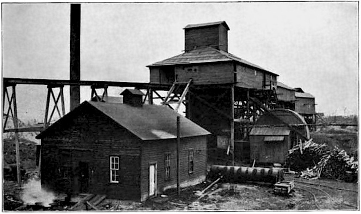
English: Original caption: "The upper works of the Relay Mine No. 3, Centerville, IA. The house in the foreground contains the hoisting engines. The shaft is in the center. The drum-like structure on the right is the fan which ventilates the mine. The trestle running to the left is for carrying away the refuse. The end of the dump pile shows just beyond the trestle. The weighing and storage sheds are beyond the shaft." |
| Fecha | |
| Fuente | An Iowa Coal Mine, Chapter V of Out of Door Studies in Geography, I, The Making of the Surface and Soils of the Upper Mississippi Region |
| Autor | Francis M. Fultz (1857-1948) |
| Posición de la cámara | | Ubicación de esta y otras imágenes en: OpenStreetMap |
|---|
location estimated from map file:CentervilleMines.png where this is known to be mine number 31, and refined using the more accurate map at the end of H. Foster Bain, Geology of Appanoose County, Iowa Geological Survey Annual Report, 1895, where it is marked as number 3.
Licencia
Este archivo está en el dominio público en los Estados Unidos. Esto se aplica a los trabajos de Estados Unidos donde los derechos de autor han expirado, a menudo porque su primera publicación ocurrió antes del 1 de enero de 1929. Véase esta página para explicación adicional.
|
 | |
 |
Esta imagen puede estar protegida fuera de los Estados Unidos —especialmente en Canadá, China (excepto Hong-Kong, Macao, o el área de Taiwán), Alemania o Suiza—. El creador y el año de publicación son información esencial y deben ser proporcionados. Véase Wikipedia:Derechos de autor para más detalles.
|
Historial del archivo
Haz clic sobre una fecha y hora para ver el archivo tal como apareció en ese momento.
| Fecha y hora | Miniatura | Dimensiones | Usuario | Comentario | |
|---|---|---|---|---|---|
| actual | 15:01 15 sep 2009 | | 736 × 437 (103 kB) | Douglas W. Jones | {{Information |Description={{en|1=Original caption" The upper works of the Relay Mine No. 3, Centerville, IA. The house in the foreground contains the hoisting engines. The shaft is in the center. The drum-like structure on the right is the fan which |
Usos del archivo
La siguiente página usa este archivo:
Uso global del archivo
Las wikis siguientes utilizan este archivo:
- Uso en de.wikipedia.org
- Uso en en.wikipedia.org