
Archivo:Salar de Atacama, Chile ESA386674.jpg

Ver la imagen en su resolución original (2000 × 2000 píxeles; tamaño de archivo: 2,13 MB; tipo MIME: image/jpeg)
Resumen
| Descripción |
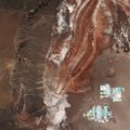
English: From the Salar de Atacama salt flat in the east to the Cordillera Domeyko mountains in the west, Sentinel-2 takes us over part of the Atacama Desert in northern Chile.
The desert runs along part of South America’s central west coast. It is considered one of the driest places on Earth. Being a ‘coastal desert’, the cold, upwelling waters in the Pacific Ocean inhibit rain from reaching the land. Instead, the winds that blow from the ocean bring fog. Because of the Atacama plateau’s high altitude, low cloud cover and lack of light pollution, it is one of the best places in the world to conduct astronomical observations and home to two major observatories. Some areas of the desert have been compared to the planet Mars, and have been used as a location for filming scenes set on the red planet. ESA has even tested a self-steering rover in the Atacama, which was selected for its similarities to martian conditions. In the lower right, the geometric shapes of large evaporation ponds dominate the Salar de Atacama –Chile’s largest salt flat. At about 3000 sq km, it is the world’s third largest salt flat as well as one of the largest active sources of lithium. From evaporation ponds like the ones pictured here, lithium bicarbonate is isolated from salt brine. Lithium is used in the manufacturing of batteries, and the increasing demand has significantly increased its value in recent years – especially for the production of electric-car batteries. This image, also featured on theEarth from Space video programme, was captured by the Copernicus Sentinel-2A satellite on 29 April 2017. |
| Fecha | |
| Fuente | http://www.esa.int/spaceinimages/Images/2017/11/Salar_de_Atacama_Chile |
| Autor | European Space Agency |
| Permiso (Reutilización de este archivo) |
contains modified Copernicus Sentinel data (2017), processed by ESA,CC BY-SA 3.0 IGO |
| Otras versiones |
|
| Title | Salar de Atacama, Chile |
| System | Copernicus |
| Set | Earth observation image of the week |
| Location | Atacama Desert |
| Mission | Sentinel-2 |
| Activity | Observing the Earth |
Licencia
This media was created by the European Space Agency (ESA).
Where expressly so stated, images or videos are covered by the Creative Commons Attribution-ShareAlike 3.0 IGO (CC BY-SA 3.0 IGO) licence, ESA being an Intergovernmental Organisation (IGO), as defined by the CC BY-SA 3.0 IGO licence. The user is allowed under the terms and conditions of the CC BY-SA 3.0 IGO license to Reproduce, Distribute and Publicly Perform the ESA images and videos released under CC BY-SA 3.0 IGO licence and the Adaptations thereof, without further explicit permission being necessary, for as long as the user complies with the conditions and restrictions set forth in the CC BY-SA 3.0 IGO licence, these including that:
See the ESA Creative Commons copyright notice for complete information, and this article for additional details.
|
 | |
Este archivo se encuentra bajo la licencia Creative Commons Atribución Compartir-Igual 3.0 IGO.
| ||

|
Esta imagen contiene datos que provienen de un satélite del Programa Copérnico, como Sentinel-1, Sentinel 2 o Sentinel-3. Se require atribución cuando se utilice esta imagen.
Atribución: Contiene datos modificados de Copernicus Sentinel 2017
El uso de datos Sentinel del Programa Cópernico está regulado por la legislación europea: Reglamento Delegado (UE) No 1159/2013 de la Comisión y el Reglamento (UE) No 377/2014. Los pasajes relevantes son:
Se permitirá el acceso gratuito a los datos dedicados del GMES y a la información de servicio del GMES a través de las plataformas de difusión del GMES [...].
Se dará acceso a los datos dedicados del GMES y a la información de servicio del GMES a los efectos que se detallan a continuación, siempre y cuando sean lícitos:
Los datos dedicados del GMES y la información de servicio del GMES podrán utilizarse en todo el mundo sin limitación de tiempo.
Los datos dedicados del GMES y la información de servicio del GMES se facilitarán a los usuarios sin ninguna garantía explícita o implícita, incluyendo lo tocante a la calidad y la idoneidad para cualesquiera fines. |
Historial del archivo
Haz clic sobre una fecha y hora para ver el archivo tal como apareció en ese momento.
| Fecha y hora | Miniatura | Dimensiones | Usuario | Comentario | |
|---|---|---|---|---|---|
| actual | 16:56 17 nov 2017 | | 2000 × 2000 (2,13 MB) | Fæ | European Space Agency, Id 386674, http://www.esa.int/spaceinimages/Images/2017/11/Salar_de_Atacama_Chile, User:Fæ/Project_list/ESA |
Usos del archivo
La siguiente página usa este archivo:
Uso global del archivo
Las wikis siguientes utilizan este archivo:
- Uso en cs.wikipedia.org
- Uso en pl.wikipedia.org