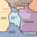
Archivo:South American plates-es.png

Contenido de la página no disponible en otros idiomas.
De Wikipedia, la enciclopedia libre

Ver la imagen en su resolución original(1440 × 1423 píxeles; tamaño de archivo: 506 kB; tipo MIME: image/png)

Resumen

Descripción The key principle of plate tectonics is that the lithosphere exists as separate and distinct tectonic plates, which float on the fluid-like (visco-elastic solid) asthenosphere. The relative fluidity of the asthenosphere allows the tectonic plates to undergo motion in different directions. This map shows 15 of the largest plates. Note that the Indo-Australian Plate may be breaking apart into the Indian and Australian plates, which are shown separately on this map.
Fecha
Fuente http://pubs.usgs.gov/publications/text/slabs.html
Autor USGS; cropped by Beyond My Ken (talk) 10:06, 27 February 2010 (UTC)
Otras versiones
Public domain
Esta imagen está en el dominio público, ya que contiene materiales que originalmente vinieron del Servicio Geológico de los Estados Unidos de América, una agencia del Departamento del Interior. Para obtener más información, consulte la política oficial de derechos de los USGS.

Bahasa Indonesia  català  čeština  Deutsch  eesti  English  español  français  galego  italiano  Nederlands  português  polski  sicilianu  suomi  Tiếng Việt  Türkçe  български  македонски  русский  മലയാളം  한국어  日本語  中文  中文(简体)  中文(繁體)  العربية  فارسی  +/−

Historial del archivo

Haz clic sobre una fecha y hora para ver el archivo tal como apareció en ese momento.

Fecha y horaMiniaturaDimensionesUsuarioComentario
actual19:51 19 mar 2022Miniatura de la versión del 19:51 19 mar 20221440 × 1423 (506 kB)Ezarate{{Information |Description= |Source= |Date= |Author= |Permission= |other_versions= }}

Metadatos