
Archivo:Zanj Rebellion.svg

Tamaño de esta previsualización PNG del archivo SVG: 750 × 600 píxeles. Otras resoluciones: 300 × 240 píxeles · 600 × 480 píxeles · 960 × 768 píxeles · 1280 × 1024 píxeles · 2560 × 2048 píxeles · 900 × 720 píxeles.
Ver la imagen en su resolución original ((Imagen SVG, nominalmente 900 × 720 pixels, tamaño de archivo: 1,2 MB))
Resumen
| Descripción |
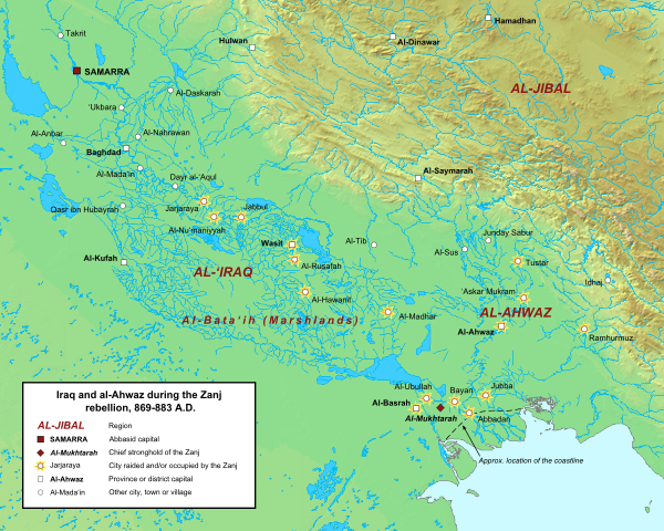
English: Map of the central Abbasid caliphate during the rebellion of the Zanj, from 869 to 883 A.D. All settlements on this map are listed by al-Tabari in his History of the Prophets and Kings, trans. "The History of al-Tabari," volumes 35 through 37. The location of cities and towns that no longer exist were determined using the maps of Le Strange and Popovic in their respective works.
Background topography taken from DEMIS Mapserver, which are public domain. Works Cited:
|
| Fecha | |
| Fuente | Trabajo propio |
| Autor | Ro4444 |
Licencia
Yo, el titular de los derechos de autor de esta obra, la publico en los términos de la siguiente licencia:
Este archivo se encuentra bajo la licencia Creative Commons Genérica de Atribución/Compartir-Igual 3.0.
- Eres libre:
- de compartir – de copiar, distribuir y transmitir el trabajo
- de remezclar – de adaptar el trabajo
- Bajo las siguientes condiciones:
- atribución – Debes otorgar el crédito correspondiente, proporcionar un enlace a la licencia e indicar si realizaste algún cambio. Puedes hacerlo de cualquier manera razonable pero no de manera que sugiera que el licenciante te respalda a ti o al uso que hagas del trabajo.
- compartir igual – En caso de mezclar, transformar o modificar este trabajo, deberás distribuir el trabajo resultante bajo la misma licencia o una compatible como el original.
Historial del archivo
Haz clic sobre una fecha y hora para ver el archivo tal como apareció en ese momento.
| Fecha y hora | Miniatura | Dimensiones | Usuario | Comentario | |
|---|---|---|---|---|---|
| actual | 14:42 16 jun 2015 | | 900 × 720 (1,2 MB) | Ro4444 | Changing location of al-Madhar to 31° 28' 23.4726" N, 47° 23' 4.4982", the location of the burial place of 'Abdallah ibn 'Ali ibn Abi Talib. See M. Streck, "Maisan," ''E.J. Brill's First Encyclopaedia of Islam, Volume V,'' (Leiden: E.J. Brill, 1927),... |
| 21:13 3 mar 2013 |  | 900 × 720 (1,2 MB) | Ro4444 | User created page with UploadWizard |
Usos del archivo
La siguiente página usa este archivo:
Uso global del archivo
Las wikis siguientes utilizan este archivo:
- Uso en ar.wikipedia.org
- Uso en arz.wikipedia.org
- Uso en azb.wikipedia.org
- Uso en ca.wikipedia.org
- Uso en cy.wikipedia.org
- Uso en de.wikipedia.org
- Uso en en.wikipedia.org
- Uso en fa.wikipedia.org
- Uso en fr.wikipedia.org
- Uso en ga.wikipedia.org
- Uso en he.wikipedia.org
- Uso en id.wikipedia.org
- Uso en ms.wikipedia.org
- Uso en pt.wikipedia.org
- Uso en sv.wikipedia.org
- Uso en tr.wikipedia.org
- Uso en www.wikidata.org
- Uso en zh.wikipedia.org