
Archivo:1793 Faden Wall Map of India - Geographicus - India-faden-1793.jpg

Tamaño de esta previsualización: 497 × 599 píxeles. Otras resoluciones: 199 × 240 píxeles · 398 × 480 píxeles · 637 × 768 píxeles · 850 × 1024 píxeles · 1700 × 2048 píxeles · 6000 × 7229 píxeles.
Ver la imagen en su resolución original (6000 × 7229 píxeles; tamaño de archivo: 9,83 MB; tipo MIME: image/jpeg)
| A Map of the Peninsula of India. | ||||||
|---|---|---|---|---|---|---|
| Artista | ||||||
| Título |
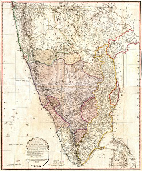
A Map of the Peninsula of India. |
|||||
| Descripción |
English: This map, created immediately after the Third Anglo-Mysore War (1789-92), shows the division of and territorial loss by the Kingdom of Mysore through the 1792 Treaty of Seringapatam.
A "third edition" was created in 1800 showing the territorial changes after the Fourth Anglo-Mysore War (1798–1799). Description from Geographicus: One of the largest and most impressive maps of India to appear in the 18th century. Depicts the subcontinent from Bombay ( Mumbai ) and Aurungabad, south including the northern half of Sri Lanka ( Ceylon ). Printed in 1793 in London by William Faden, “Royal Geographer to the King and to the Prince of Wales”. Includes the routes of various military marches and campaigns including the 1784 March of British Prisoners from Condapoor to Madras, the march of the Marquis of Cornwallis, the march of General Medows, and the march of General Abercromby. Also shows the acquisitions of the British through the Partition Treaty of 1792. The whole is masterfully presented in visually stunning almost three dimensional detail and stunning period color. A must for any serious collection of south Asia maps. Compiled chiefly from papers communicated by the late Sir Archd. Campbell, the surveys of Col. Kelly, Capt. Pringle, Capt. Allan, etc. |
|||||
| Fecha | 1793 (dated) | |||||
| Dimensiones | altura: 39 in (99 cm); ancho: 32 in (81,2 cm) | |||||
| Número de inventario |
Geographicus link: India-faden-1793 |
|||||
| Fuente/fotógrafo |
|
|||||
| Permiso (Reutilización de este archivo) |
|
|||||
| Otras versiones |
|
|||||

Historial del archivo
Haz clic sobre una fecha y hora para ver el archivo tal como apareció en ese momento.
| Fecha y hora | Miniatura | Dimensiones | Usuario | Comentario | |
|---|---|---|---|---|---|
| actual | 10:16 24 mar 2011 | | 6000 × 7229 (9,83 MB) | BotMultichillT | {{subst:User:Multichill/Geographicus |link=http://www.geographicus.com/P/AntiqueMap/India-faden-1793 |product_name=1793 Faden Wall Map of India |map_title=A Map of the Peninsula of India. |description=One of the largest and most impressive maps of India t |
Usos del archivo
La siguiente página usa este archivo:
Uso global del archivo
Las wikis siguientes utilizan este archivo:
- Uso en ar.wikipedia.org
- Uso en azb.wikipedia.org
- Uso en br.wikipedia.org
- Uso en ca.wikipedia.org
- Uso en de.wikipedia.org
- Uso en en.wikipedia.org
- Uso en fa.wikipedia.org
- Uso en fr.wikipedia.org
- Uso en it.wikipedia.org
- Uso en ja.wikipedia.org
- Uso en ml.wikipedia.org
- Uso en mr.wikipedia.org
- Uso en pa.wikipedia.org
- Uso en pnb.wikipedia.org
- Uso en ru.wikipedia.org
- Uso en ta.wikipedia.org
- Uso en te.wikipedia.org
- Uso en uk.wikipedia.org
- Uso en ur.wikipedia.org