
Archivo:1818 Pinkerton Map of the Northern United States - Geographicus - USANorthernPart-pinkerton-1818.jpg

Tamaño de esta previsualización: 800 × 587 píxeles. Otras resoluciones: 320 × 235 píxeles · 640 × 470 píxeles · 1024 × 752 píxeles · 1280 × 940 píxeles · 2560 × 1879 píxeles · 5000 × 3670 píxeles.
Ver la imagen en su resolución original (5000 × 3670 píxeles; tamaño de archivo: 4,69 MB; tipo MIME: image/jpeg)
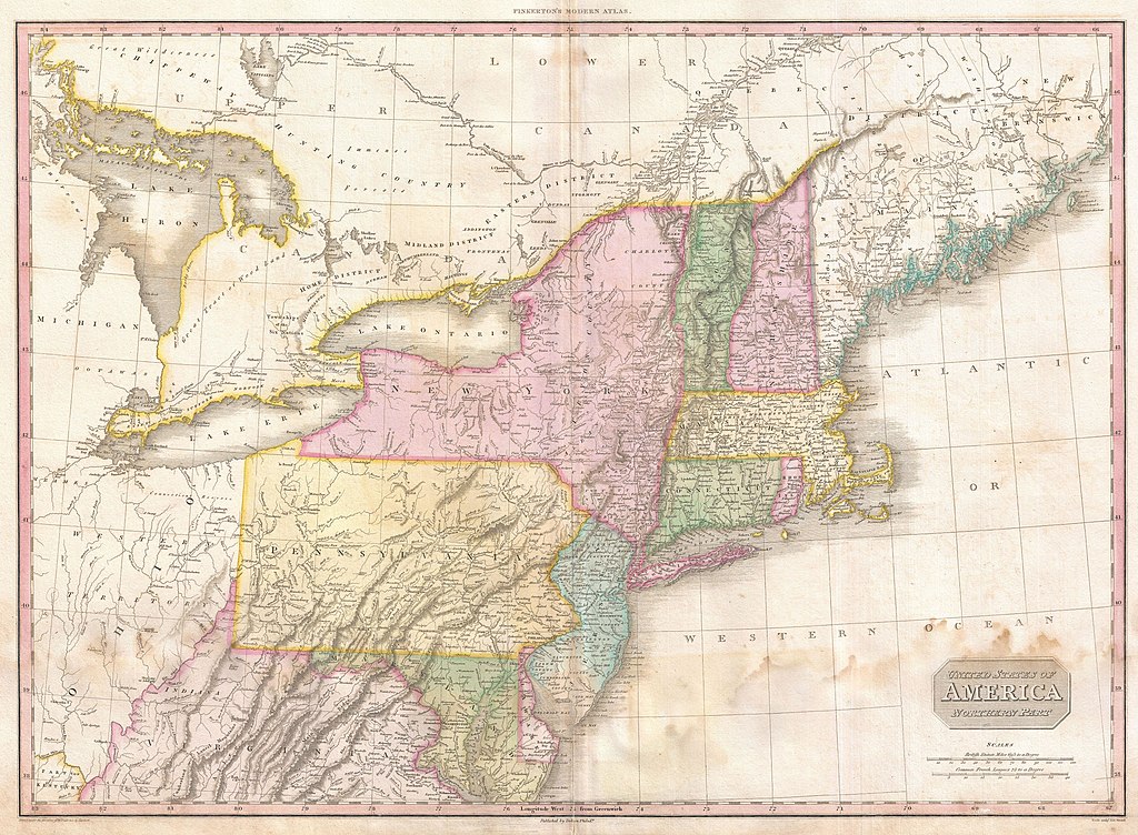
| John Pinkerton: United States of America Northern Part.
( |
|||||||||||||||||||||
|---|---|---|---|---|---|---|---|---|---|---|---|---|---|---|---|---|---|---|---|---|---|
| Artista |
|
||||||||||||||||||||
| Título |
United States of America Northern Part. |
||||||||||||||||||||
| Descripción |
English: John Pinkerton's highly decorative and important map of the northern parts of the United States, published 1818. Covers from Lake Huron eastward as far as New Brunswick and southwards as far as the Chesapeake Bay. Includes the states of New York, New Jersey, Pennsylvania, Connecticut, Rhode Island, Vermont, New Hampshire, Maryland, Delaware and Virginia. Also includes the districts of Maine, parts of the Western Territory, including Michigan and Ohio, and adjacent portions of Canada. Pinkerton's map is full of interesting detail from the American Indian lands in the western portions of the map, to notations on river navigation, to the configuration of the early states. Notes Connecticut's Western reserve in what is today Ohio. This territory was a legacy of Connecticut's original coast to coast charter and we settled in the early 19th century by New England emigrants. Drawn by L. Herbert and engraved by Samuel Neele under the direction of John Pinkerton. This map comes from the scarce American edition of Pinkerton’s Modern Atlas, published by Thomas Dobson & Co. of Philadelphia in 1818. |
||||||||||||||||||||
| Fecha | 1818 (undated) | ||||||||||||||||||||
| Dimensiones | altura: 20,5 in (52 cm); ancho: 28 in (71,1 cm) | ||||||||||||||||||||
| Número de inventario |
Geographicus link: USANorthernPart-pinkerton-1818 |
||||||||||||||||||||
| Fuente/fotógrafo |
Pinkerton, J., A Modern Atlas, from the Lates and Best Authorities, Exhibiting the Various Divisions of the World with its chief Empires, Kingdoms, and States; in Sixty Maps, carefully reduced from the Larges and Most Authentic Sources. 1818, Philadelphia, Thomas Dobson Edition.
|
||||||||||||||||||||
| Permiso (Reutilización de este archivo) |
|
||||||||||||||||||||

Historial del archivo
Haz clic sobre una fecha y hora para ver el archivo tal como apareció en ese momento.
| Fecha y hora | Miniatura | Dimensiones | Usuario | Comentario | |
|---|---|---|---|---|---|
| actual | 06:54 23 mar 2011 | | 5000 × 3670 (4,69 MB) | BotMultichillT | {{subst:User:Multichill/Geographicus |link=http://www.geographicus.com/P/AntiqueMap/USANorthernPart-pinkerton-1818 |product_name=1818 Pinkerton Map of the Northern United States |map_title=United States of America Northern Part. |description=John Pinkerto |
Usos del archivo
La siguiente página usa este archivo: