
Archivo:1860 Mitchell Map of New York City, New York (first edition) - Geographicus - NYC-mitchell-1860.jpg

Tamaño de esta previsualización: 501 × 600 píxeles. Otras resoluciones: 200 × 240 píxeles · 401 × 480 píxeles · 642 × 768 píxeles · 855 × 1024 píxeles · 1711 × 2048 píxeles · 2924 × 3500 píxeles.
Ver la imagen en su resolución original (2924 × 3500 píxeles; tamaño de archivo: 3,74 MB; tipo MIME: image/jpeg)
_-_Geographicus_-_NYC-mitchell-1860.jpg?uselang=es)
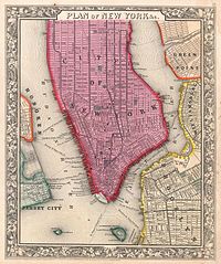
| Samuel Augustus Mitchell: Plan of New York & c.
( |
||||||||||||||||||||
|---|---|---|---|---|---|---|---|---|---|---|---|---|---|---|---|---|---|---|---|---|
| Artista |
|
|||||||||||||||||||
| Título |
Plan of New York & c. |
|||||||||||||||||||
| Descripción |
English: A beautiful example of the first edition of S. A. Mitchell’s 1860 map of New York City. Depicts New York City along with parts of Brooklyn, Williamsburg, Greenpoint, Hoboken and Jersey City. Offers wonderful detail at the street level including references to parks, individual streets, piers, ferries, and important buildings. Colored coded with pastels according to towns. Surrounded by the attractive floral border common to Mitchell atlases between 1860 and 1865. This variant differs from later examples (1861-2) of Mitchell’s New York in that city wards are not defined. One of the more attractive atlas maps of New York to appear in the mid 19th century. Prepared by S. A. Mitchell Jr. for inclusion as plate 16 in the 1860 issue of Mitchell’s New General Atlas . Dated and copyrighted, “Entered according to Act of Congress in the Year 1860 by S. Augustus Mitchell Jr. in the Clerk’s Office of the District Court of the U.S. for the Eastern District of Pennsylvania. |
|||||||||||||||||||
| Fecha | 1860 (dated) | |||||||||||||||||||
| Dimensiones | altura: 13 in (33 cm); ancho: 11 in (27,9 cm) | |||||||||||||||||||
| Número de inventario |
Geographicus link: NYC-mitchell-1860 |
|||||||||||||||||||
| Fuente/fotógrafo |
Mitchell Jr., S. A., Mitchell's New General Atlas, Containing Maps Of The Various Countries Of The World, Plans Of Cities, Etc. Embraced In Forty-Seven Quarto Maps, Forming A Series Of Seventy-Six Maps And Plans, Together With Valuable Statistical Tables. (1860 First Edition)
|
|||||||||||||||||||
| Permiso (Reutilización de este archivo) |
|
|||||||||||||||||||
Historial del archivo
Haz clic sobre una fecha y hora para ver el archivo tal como apareció en ese momento.
| Fecha y hora | Miniatura | Dimensiones | Usuario | Comentario | |
|---|---|---|---|---|---|
| actual | 15:05 22 mar 2011 | | 2924 × 3500 (3,74 MB) | BotMultichillT | {{subst:User:Multichill/Geographicus |link=http://www.geographicus.com/P/AntiqueMap/NYC-mitchell-1860 |product_name=1860 Mitchell Map of New York City, New York (first edition) |map_title=Plan of New York & c. |description=A beautiful example of the first |
Usos del archivo
La siguiente página usa este archivo:
Uso global del archivo
Las wikis siguientes utilizan este archivo:
- Uso en en.wikipedia.org
- Uso en it.wikipedia.org
- Uso en tr.wikipedia.org
_-_Geographicus_-_NYC-mitchell-1860.jpg)