
Archivo:Bastogne Map December 19-23 1944.jpg
Tamaño de esta previsualización: 800 × 477 píxeles. Otras resoluciones: 320 × 191 píxeles · 640 × 381 píxeles · 1024 × 610 píxeles · 1556 × 927 píxeles.
Ver la imagen en su resolución original (1556 × 927 píxeles; tamaño de archivo: 1,19 MB; tipo MIME: image/jpeg)
Resumen
| Descripción | ||||||||||
| Fecha | ||||||||||
| Fuente | United States Army Center of Military History | |||||||||
| Creador | ||||||||||
| Geotemporal data | ||||||||||
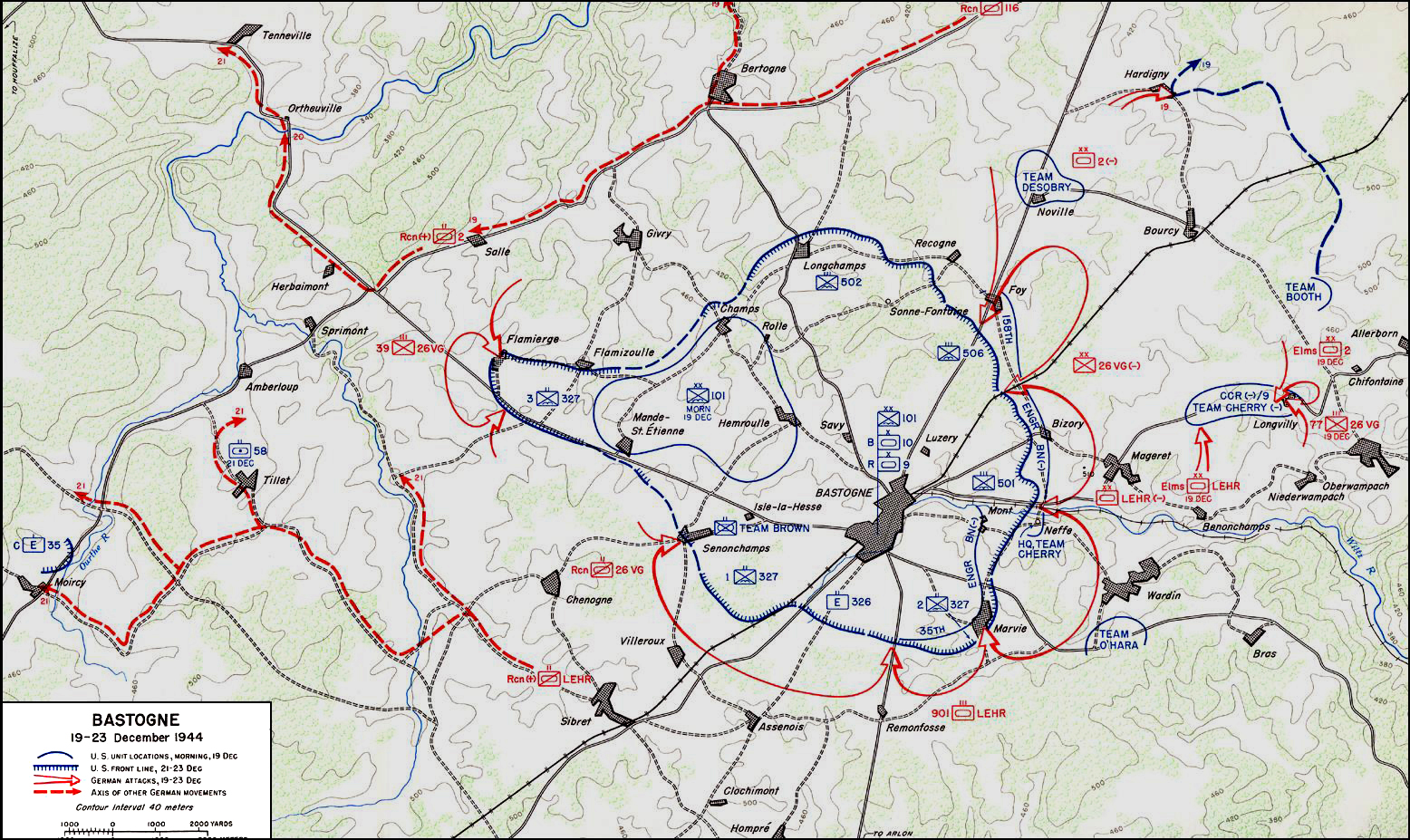
| Fecha representada | de 19 de diciembre de 1944 a 23 de diciembre de 1944 | |||||||||
| Map location | Bastoña | |||||||||
| Heading |
 |
|||||||||
| Bounding box |
|
|||||||||
| Georeferencing | ||||||||||

|
Esta imagen debería volverse a crear como imágenes vectoriales SVG. Esto proporciona muchas ventajas, véase Commons:Media for cleanup (en inglés) para más información. Si ya hay una versión SVG de esta imagen disponible, por favor súbala a Commons. Tras subirla, reemplace esta plantilla con la plantilla
{{vector version available|nuevo nombre de imagen.svg}} en esta imagen. |


Licencia
| This image is in the public domain because it contains materials that originally came from the United States Army Center of Military History, subject to the following qualification.
Note: The images of all badges, insignia, decorations and medals on the "CMH Online" web site are produced by the United States Army Institute of Heraldry and protected by Title 18, United States Code, Section 704 and the Code of Federal Regulations (32 CFR, Part 507). Permission to use these images for commercial purposes must be obtained from The Institute of Heraldry prior to their use. |

|
Historial del archivo
Haz clic sobre una fecha y hora para ver el archivo tal como apareció en ese momento.
| Fecha y hora | Miniatura | Dimensiones | Usuario | Comentario | |
|---|---|---|---|---|---|
| actual | 04:59 4 nov 2006 | | 1556 × 927 (1,19 MB) | CORNELIUSSEON | {{Information |Description=Bastogne, Belgium Map; december 19-23, 1944. |Source=US Army Center for Military History |Date=December 19-23, 1944 |Author= |Permission={{PD-USGov-Military-Army-USACMH}} – US Army Center for Military History |other_versions= |
Usos del archivo
La siguiente página usa este archivo:
Uso global del archivo
Las wikis siguientes utilizan este archivo:
- Uso en ar.wikipedia.org
- Uso en ca.wikipedia.org
- Uso en de.wikipedia.org
- Uso en el.wikipedia.org
- Uso en en.wikipedia.org
- Uso en en.wikisource.org
- Uso en he.wikipedia.org
- Uso en it.wikipedia.org
- Uso en ja.wikipedia.org
- Uso en nl.wikipedia.org
- Uso en ru.wikipedia.org
- Uso en sl.wikipedia.org
- Uso en ta.wikipedia.org
- Uso en tr.wikipedia.org
- Uso en www.wikidata.org
- Uso en zh.wikipedia.org