
Archivo:Big Thomson Mesa, Capitol Reef National Park, Utah.jpg
Ver la imagen en su resolución original (4256 × 2832 píxeles; tamaño de archivo: 1,36 MB; tipo MIME: image/jpeg)
Resumen
| Descripción |
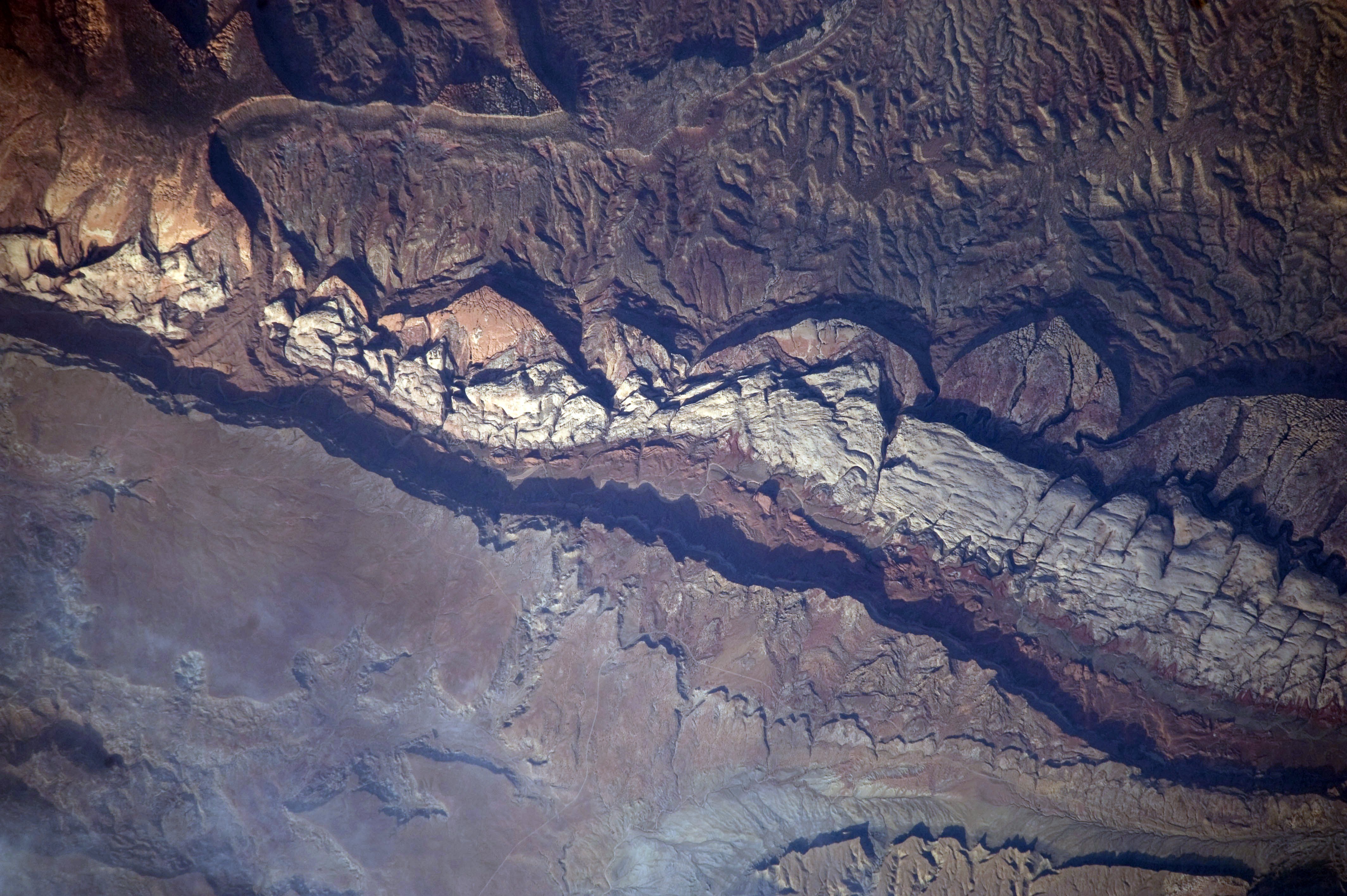
English: This detailed astronaut photograph shows part of Big Thomson Mesa, near the southern end of Capitol Reef National Park. Capitol Reef National Park is located on the Colorado Plateau, which occupies the adjacent quarters of Arizona, Colorado, New Mexico, and Utah. Big Thomson Mesa (image left) is part of a large feature known as the en:Waterpocket Fold. The Fold is a geologic structure called a monocline—layers of generally flat-lying sedimentary rock with a steep, one-sided bend, like a carpet runner draped over a stair step. Geologists think that monoclines on the Colorado Plateau result from faulting (cracking) of deeper and more brittle crystalline rocks under tectonic pressure; while the crystalline rocks were broken into raised or lowered blocks, the overlaying, less brittle sedimentary rocks were flexed without breaking.
The portion of the Waterpocket Fold illustrated in this image includes layered rocks formed during the Mesozoic Era (about 250 – 65 million years ago). The oldest layers are at the bottom of the sequence, with each successive layer younger than the preceding one going upwards in the sequence. Not all of the formation’s rock layers are clearly visible, but some of the major layers (units to geologists) can be easily distinguished. The top half of the image includes the oldest rocks in the view: dark brown and dark green Moenkopi and Chinle Formations. Moving toward the foot of the mesa, two strikingly coloured units are visible near image centre: light red to orange Wingate Sandstone and white Navajo Sandstone. Beyond those units, reddish brown to brown Carmel Formation and Entrada Sandstone occupy a topographic bench at the foot of a cliff. The top of the cliff face above this bench—Big Thomson Mesa—is comprised of brown Dakota Sandstone. This sequence represents more than 100 million years of sediments being deposited and turned into rock. Much younger Quaternary (2-million- to approximately 10,000-year-old) deposits are also present in the view. The area shown in this astronaut photograph is located approximately 65 kilometers to the southeast of Fruita, UT near the southern end of Capitol Reef National Park.
|
||||||||||||||||||||||||||||||||||||||||||||||||||
| Fecha | |||||||||||||||||||||||||||||||||||||||||||||||||||
| Fuente | NASA Earth Observatory | ||||||||||||||||||||||||||||||||||||||||||||||||||
| Autor | This image was taken by the NASA Expedition 20 crew | ||||||||||||||||||||||||||||||||||||||||||||||||||
| Posición de la cámara | | Ubicación de esta y otras imágenes en: OpenStreetMap |
|---|
Este archivo fue catalogado por Johnson Space Center de la Administración Nacional de Aeronáutica y del Espacio (NASA) de los Estados Unidos de Américabajo el identificador de foto: ISS020-E-9861.Esta etiqueta no indica el estado de los derechos de autor del trabajo adjunto. Se requiere una etiqueta de derechos de autor normal. Para más información vea Commons:Sobre las licencias. Otros idiomas:
|
Image acquired with a Nikon D3 digital camera fitted with an 800 mm lens, and is provided by the ISS Crew Earth Observations experiment and Image Science & Analysis Laboratory, Johnson Space Centre.
Licencia
| Este archivo es de dominio público porque fue creado por la NASA. Las políticas sobre copyright de la NASA estipulan que «el material de la NASA no está protegido con copyright a menos que se indique lo contrario». (Políticas sobre copyright de la NASA o Políticas sobre la utilización de imágenes del Jet Propulsion Laboratory). | ||
 |
Advertencias:
|
Historial del archivo
Haz clic sobre una fecha y hora para ver el archivo tal como apareció en ese momento.
| Fecha y hora | Miniatura | Dimensiones | Usuario | Comentario | |
|---|---|---|---|---|---|
| actual | 12:56 31 ene 2011 | | 4256 × 2832 (1,36 MB) | Originalwana | higher res |
| 18:04 6 jul 2009 |  | 1440 × 960 (1,02 MB) | Originalwana | {{Information |Description={{en|1=This detailed astronaut photograph shows part of Big Thomson Mesa, near the southern end of Capitol Reef National Park. Capitol Reef National Park is located on the Colorado Plateau, which occupies the adjacent quarters o |
Usos del archivo
La siguiente página usa este archivo:
Uso global del archivo
Las wikis siguientes utilizan este archivo:
- Uso en ar.wikipedia.org
- Uso en en.wikipedia.org
- Uso en en.wikiversity.org
- Uso en fr.wikipedia.org
- Uso en he.wikipedia.org
- Uso en is.wikipedia.org
- Uso en pt.wikipedia.org