
Archivo:Byzantine Constantinople-el.svg

Tamaño de esta previsualización PNG del archivo SVG: 662 × 600 píxeles. Otras resoluciones: 265 × 240 píxeles · 530 × 480 píxeles · 848 × 768 píxeles · 1130 × 1024 píxeles · 2261 × 2048 píxeles · 2606 × 2361 píxeles.
Ver la imagen en su resolución original ((Imagen SVG, nominalmente 2606 × 2361 pixels, tamaño de archivo: 806 kB))
Resumen
| Descripción |
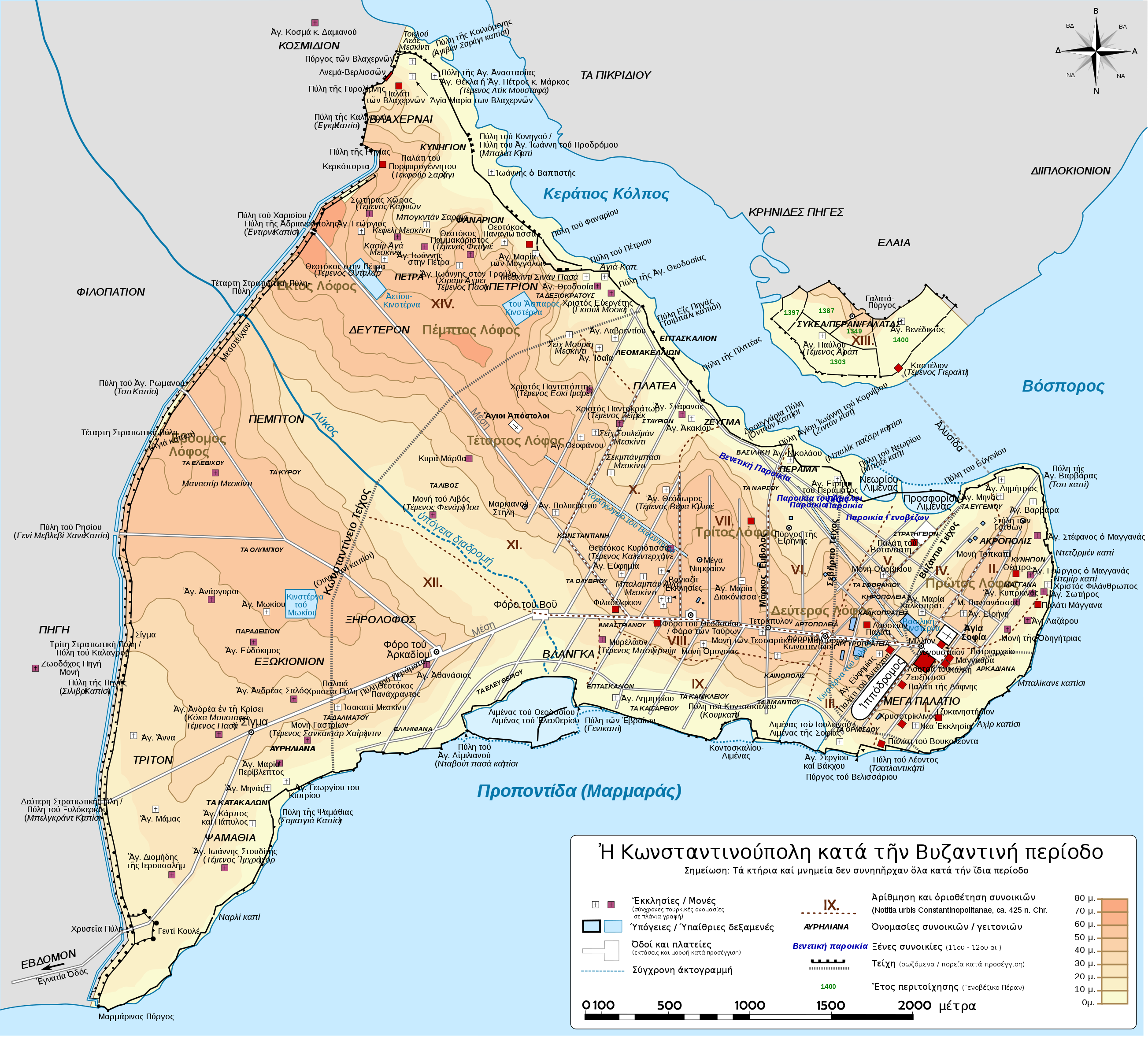
Deutsch: Topografische Karte Konstantinopels während des byzantinischen Zeitraums. Quelle: R. Janin, Constantinople Byzantine. Developpement urbain et repertoire topographique. Straßennetz und andere Einzelheiten basiert auf Dumbarton Oaks Papers 54. Kirchen, insb. nicht identifizierte und ausgegrabene Bauten sind aus dem The Byzantine Churches of Istanbul entnommen. Andere herausgegebenen Quellen wurden behilfsmäßig gebraucht. English: Topographical map of Constantinople (in Greek) during the Byzantine period. Main map source: R. Janin, Constantinople Byzantine. Developpement urbain et repertoire topographique. Road network and some other details based on Dumbarton Oaks Papers 54; data on many churches, especially unidentified ones, taken from the University of New York's The Byzantine Churches of Istanbul project. Other published maps and accounts of the city have been used for corroboration. Français : Carte en anglais de Constantinople à l'époque Byzantine. Source principale : R. Janin, Constantinople Byzantine. Développement urbain et répertoire topographique. Le réseau routier et d'autres détails proviennent de Dumbarton Oaks Papers 54. Les données concernant de nombreuses églises, en particulier celles non identifiées, viennent de l'université de New York : le projet The Byzantine Churches of Istanbul (Les églises byzantines d'Istanbul). D'autres cartes encore ont été utilisées pour recouper et vérifier les informations. Türkçe: Konstantinopolis'in Bizans dönemindeki topografik haritası. Ana haritanın kaynağı: R. Janin, Constantinople Byzantine. Developpement urbain et repertoire topographique. Yol haritası ve bazı diğer ayrıntıların kaynağı: Dumbarton Oaks Papers 54; kiliseler, özellikle kimliği belirlenmemiş olanlar hakkında veriler, New York University'nin İstanbul'un Bizans Kiliseleri projesinden elde edilmiştir. Şehir hakkında yayımlanmış diğer harita ve metinler bu bilgileri doğrulamak için kullanılmıştır. Ελληνικά: Τοπογραφικός χάρτης Κωνσταντινουπόλεως κατά τη Βυζαντινή περίοδο. Βασική πηγή χάρτη: R. Janin, Constantinople Byzantine. Developpement urbain et repertoire topographique. Το οδικό δίκτυο και διάφορες άλλες λεπτομέρειες με βάση το Dumbarton Oaks Papers 54. Πληροφορίες για τις εκκλησίες, ιδιαίτερα τις μη ταυτοποιημένες, από την ιστοσελίδα The Byzantine Churches of Istanbul του Πανεπιστημίου της Νέας Υόρκης. Беларуская: Мапа Канстанцінопаля часоў Візантыі. Беларуская (тарашкевіца): Мапа Канстантынопаля часоў Візантыі. Български: Топографска карта на Константинопол (Цариград) през византийския период. Източник: R. Janin, Constantinople Byzantine. Developpement urbain et repertoire topographique. Пътната мрежа и някои други детайли се основават на Dumbarton Oaks Papers 54 и други публикувани източници. Русский: Карта Константинополя времён Византии. Українська: Мапа Константинополя часів Візантії. |
| Fecha | |
| Fuente |
Este archivo deriva de: Byzantine Constantinople-de.svg: |
| Autor |
|
| Otras versiones |
[] Full mapsSVG:
PNG:
Numeric versions
Regions
Roads
|


Licencia
Este archivo se encuentra bajo la licencia Creative Commons Atribución 3.0 Unported.
- Eres libre:
- de compartir – de copiar, distribuir y transmitir el trabajo
- de remezclar – de adaptar el trabajo
- Bajo las siguientes condiciones:
- atribución – Debes otorgar el crédito correspondiente, proporcionar un enlace a la licencia e indicar si realizaste algún cambio. Puedes hacerlo de cualquier manera razonable pero no de manera que sugiera que el licenciante te respalda a ti o al uso que hagas del trabajo.
Historial del archivo
Haz clic sobre una fecha y hora para ver el archivo tal como apareció en ese momento.
| Fecha y hora | Miniatura | Dimensiones | Usuario | Comentario | |
|---|---|---|---|---|---|
| actual | 17:10 16 may 2016 | | 2606 × 2361 (806 kB) | Gts-tg | Typo fix |
| 11:44 3 may 2016 |  | 2606 × 2361 (940 kB) | Gts-tg | Typo fix | |
| 11:40 3 may 2016 |  | 2606 × 2361 (940 kB) | Gts-tg | Further positioning fixes | |
| 11:35 3 may 2016 |  | 2606 × 2361 (943 kB) | Gts-tg | Positioning fixes | |
| 11:04 3 may 2016 |  | 2606 × 2361 (948 kB) | Gts-tg | User created page with UploadWizard |
Usos del archivo
Las siguientes páginas usan este archivo:
Uso global del archivo
Las wikis siguientes utilizan este archivo:
- Uso en el.wikipedia.org
- Σεπτέμβριος
- Κωνσταντινούπολη
- Στάση του Νίκα
- Αγία Σοφία (Κωνσταντινούπολη)
- Άλωση της Κωνσταντινούπολης (1453)
- Τείχη της Κωνσταντινούπολης
- Σφαγή των Λατίνων
- Πολιορκία της Κωνσταντινούπολης (717-718)
- Πολιορκία της Κωνσταντινούπολης (674-678)
- Επτά λόφοι της Κωνσταντινούπολης
- Λύκος (ποταμός Κωνσταντινούπολης)
- Πολιορκία της Κωνσταντινούπολης (626)
- Φόρος του Βοός
- Κινστέρνα του Μωκίου
- Λιμένας του Ελευθερίου
- Πηγή (συνοικία)
- Φιλοπάτιον
- Κοσμίδιον
- Τα Διακονίσσης
- Βυζαντινή Κωνσταντινούπολη
- Πρότυπο:Χρονολόγιο βυζαντινής Κωνσταντινούπολης
- Κιστέρνα του Αετίου
- Κιστέρνα του Άσπαρος
- Μάγγανα (Κωνσταντινούπολη)
- Τα Αμαστριανού
- Κοντοσκάλιον
- Λιμένας των Νεωρίων
- Λιμένας του Προσφόριου
- Εξωκιόνιον