
Archivo:Peters projection, date line in Bering strait.svg

Tamaño de esta previsualización PNG del archivo SVG: 800 × 545 píxeles. Otras resoluciones: 320 × 218 píxeles · 640 × 436 píxeles · 1024 × 697 píxeles · 1280 × 871 píxeles · 2560 × 1743 píxeles · 1613 × 1098 píxeles.
Ver la imagen en su resolución original ((Imagen SVG, nominalmente 1613 × 1098 pixels, tamaño de archivo: 808 kB))
Resumen
| Descripción |
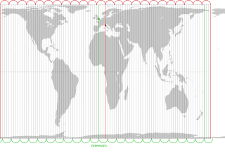
English: The Peters projection with corrected date line in the Bering strait, 168°45' West of Greenwich, proposed by Arno Peters. On his world map the easternmost part of Russia is not displayed left of Alaska, as it is usually done. Instead, it is on the right with the rest of Russia. The antipode of Peters' corrected date line is the meridian, 11° 15' East of Greenwich, traversing the city center of Florence in Italy.
The drawn out 96 meridians mark quarters of the hour. Green: Longitude of Greenwich and the old date line. Red: Longitude of Florence and Peters date line.Deutsch: Die Peters-Projektion mit korrigierter Datumsgrenze in der Beringstraße, 168°45' westlich von Greenwich. Diese wurde von Arno Peters vorgeschlagen, damit die Ostspitze Russlands auf der Weltkarte nicht wie sonst üblich abgeschnitten und links von Alaska dargestellt wird.
Die Antipode zu Peters' korrigierter Datumsgrenze ist der Meridian 11° 15' östlich von Greenwich, der durch das Stadtzentrum von Florenz in Italien verläuft. Die ausgezogenen 96 Meridiane markieren Viertelstunden. Grün: Länge von Greenwich und alte Datumsgrenze. Rot. Länge von Florenz und korrigierte Datumsgrenze in der Beringstraße. |
| Fecha | |
| Fuente | Own work by uploader. On this Peters map you can see the corrected date line |
| Autor | Watchduck |
| Otras versiones | Obras derivadas de ésta: Peters projection, blank.svg |
Licencia
| Yo, el titular de los derechos de autor de esta obra, lo libero al dominio público. Esto aplica en todo el mundo. En algunos países esto puede no ser legalmente factible; si ello ocurriese: Concedo a cualquier persona el derecho de usar este trabajo para cualquier propósito, sin ningún tipo de condición al menos que éstas sean requeridas por la ley. |
Historial del archivo
Haz clic sobre una fecha y hora para ver el archivo tal como apareció en ese momento.
| Fecha y hora | Miniatura | Dimensiones | Usuario | Comentario | |
|---|---|---|---|---|---|
| actual | 22:27 13 mar 2009 | | 1613 × 1098 (808 kB) | Watchduck | |
| 17:11 13 mar 2009 |  | 1613 × 1098 (1,85 MB) | Watchduck | ||
| 15:54 13 mar 2009 |  | 1613 × 1190 (1,85 MB) | Watchduck | {{Information |Description={{en|1=The Peters projection with corrected date line in the Bering strait, 168°45' West of Greenwich, proposed by Arno Peters not to |
Usos del archivo
La siguiente página usa este archivo:
Uso global del archivo
Las wikis siguientes utilizan este archivo:
- Uso en ca.wikipedia.org
- Uso en en.wikipedia.org
- Uso en eo.wikipedia.org
- Uso en fi.wikipedia.org
- Uso en fr.wikipedia.org
- Uso en he.wikipedia.org
- Uso en id.wikipedia.org
- Uso en it.wikipedia.org
- Uso en la.wikipedia.org
- Uso en nds-nl.wikipedia.org
- Uso en oc.wikipedia.org
- Uso en pt.wikipedia.org
- Uso en ru.wikipedia.org
- Uso en sq.wikipedia.org
- Uso en tr.wikipedia.org
- Uso en zh.wikipedia.org