
Archivo:Ray Roberts Lake Texas.jpg

Tamaño de esta previsualización: 800 × 533 píxeles. Otras resoluciones: 320 × 213 píxeles · 640 × 427 píxeles · 1024 × 683 píxeles · 1500 × 1000 píxeles.
Ver la imagen en su resolución original (1500 × 1000 píxeles; tamaño de archivo: 174 kB; tipo MIME: image/jpeg)
| Descripción |
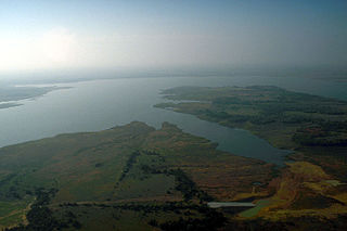
English: Aerial view of Ray Roberts Lake on the Elm Fork of the Trinity River in Denton County, Texas, USA. The dam, visible in the distance, is over 2 miles (3.2 km) long. The lake also backs up into Cooke and Grayson Counties. The U.S. Army Corps of Engineers constructed the dam in 1987 to provide water supply for the cities of Denton and Dallas. View is to the north.
Coordinates: 33°22′11″N 97°03′23″W / 33.36972°N 97.05639°W |
|||
| Localización | Denton County, Texas, USA | |||
| Fecha | not specified or unknown | |||
| Fuente |
U.S. Army Corps of Engineers Digital Visual Library Image page Image description page Digital Visual Library home page |
|||
| Autor | U.S. Army Corps of Engineers, photographer not specified or unknown | |||
| Permiso (Reutilización de este archivo) |
|
Historial del archivo
Haz clic sobre una fecha y hora para ver el archivo tal como apareció en ese momento.
| Fecha y hora | Miniatura | Dimensiones | Usuario | Comentario | |
|---|---|---|---|---|---|
| actual | 17:37 19 may 2007 | | 1500 × 1000 (174 kB) | DanMS | {{Information | Description = {{en|Aerial view of Ray Roberts Lake on the Elm Fork in Denton County, Texas, USA. The dam, visiblie in the distance, is over 2 miles (3.2 km) long. The lake also backs up into Cooke and Grayson Counties. The U.S. Army Cor |
Usos del archivo
La siguiente página usa este archivo:
Uso global del archivo
Las wikis siguientes utilizan este archivo:
- Uso en en.wikipedia.org
- Uso en www.wikidata.org